Monday 21 November 2016:
Day 1: Bairnsdale to Ensay, via rail trail to Bruthen. “You can never have too many shifters”
83kms, 877m total climbing, 645m total descending, 230m elevation gained, avg 15.7kmh.
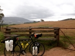
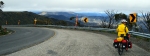
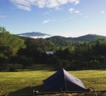
After a lovely hosting by Dad’s old university friends Tim and Jayne in Eagle Point, Jordy dropped Michael and Billy off at a non-descript Bairnsdale oval. Luckily it was right at the rail trail. By a 9:30 start it was already heating up. First 8kms to Nicholson were on a cruisy bitumen track with us getting used to the bikes (and the weight) again. It was a wake-up call after yesterday’s ‘Ride with Greenedge’ at Mitchellton winery, where we cruised 60kms without panniers. After crossing the Nicholson River on a magnificent bridge we were on gravel and taking it pretty easy, with the sun shining through the intermittent line of shade provided. We came upon a couple with twice the bags and weight we had – and they were about three quarters of the way through a 12 month tour of Australia! We snuck along with them for a little while, then wound our way into Bruthen; stop #1. We were pretty happy with the 30kms clocked up – we lunched on the green and Dad grabbed a tea-towel from the op-shop to use as a bandana; the map of Queensland printed on it was not going to help us much though. Our ninety degree turn North was the beginning of the Great Alpine Road (B500) and meant we were back on a road, sharing with log trucks of salvaged burned timber and a few other utes and cars. At the top of the first climb (a shock to the system) Dad decided the chromed steel shifter discarded on the side of the road was worth picking up – as if we didn’t have enough weight! The road was lovely, through thick forest with some challenging undulations. Dad was over-heating (and fair enough) in the 37 degree sun so we had frequent stops, water dousings in the Tambo River, and snacks to keep up energy. The day was certainly mostly uphill, and the kilometres were being counted down given it was a long gap between Bruthen and our destination of Ensay. An energetic red-bellied black snake slithered alongside us with its head raised – luckily we were on a flat and we could outpace it. Our entry to Ensay was an anti-climax as it really consisted of just a few scattered houses, a general store shut in 1983 [or was it 1883?] and post-office relocated into the Little River Inn pub. We had no energy to get to Swifts Creek and wouldn’t have made shop closing time anyway, so luckily our publican Graeme was accommodating despite no rooms or meals being available. After a cold beer and even colder shower [by choice] we were feeling better and chatted with the local fellahs at the bar for the evening – Ensay’s ‘Men’s Shed’ it seems. A ham toastie just satiated our hunger, but we were in the tent early trying to sleep and hoping the mosquito plague would not ram down the mesh ‘door’. Dad’s finder’s-keeper shifter had probably slowed him down up the hills, but strangely hadn’t quickened his pace down them…?
-

- Annemeike Van Vleuten, Greenedge Mitchellton
-

- Day 1 Heating up
-

- Day 1 Water break
-

- Day 1 Camping
-

- Day 1 Montage
Day 2: Ensay to Omeo. 45kms, via Swifts Creek, Cassilis. “Is the steady ascent better than the steep climb?”
50kms, 882m total climbing, 510m total descending, 374m elevation gained, avg 16.2 kmh.
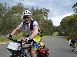
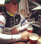
First night in the tent turned out fine, with any snoring sounds masked by the hotel’s chiller compressor (I think we slept too deeply anyway). With a cup of tea brewed on the trangia we set off in decent time. Thankfully the mercury had dropped – just a bit muggy with some welcome clouds. The road to ‘Swifts’ was not nearly as hilly as expected, so with some nice valley-vistas we cruised at a decent 18km/h and arrived before the school-kids. At the general store we got the day’s supplies – including milk for our muesli breakfast – and promptly sat for a picnic on the bench in front, watching the little town start its day. The previous evening’s pub straw-poll had suggested following the B500 to Omeo; a long slow climb versus the alternate sharp, steep climb on Cassilis Road. However, local knowledge with cycling experience from one old fellah who chatted while we munched our breakfast, determined the ‘back way’ was more enjoyable. We took it, winding on a much quieter road in some very beautiful and haunted former gold-digging territory. Tongio West and Cassilis are pretty much just dots on the map now, after housing over a thousand people during their short-lived gold rush days of the early 1900s. The road-side info-board showed denuded forests and told of high arsenic and sulphur concentrations resulting from fluvial processing – a very destructive practice. The ‘short, sharp’ climb certainly proved sharp. We were straight into the ‘dinner-plate’ gear and pushing up a 12-15% grade at 6-7km/h. Both sweating buckets by the top, a gain of 300m elevation yielded a rewarding view. The vegetation was changing to alpine, with more wildflowers and grasses appearing on the roadside in lovely bloom. Despite the rigorous climb, the route was definitely the right choice, with very little traffic and genuinely peaceful riding. We had to ascend another steep hill into Omeo, but knowing we were almost there pulled us along. The Omeo Visitor Info staffer suggested that the weather was about to turn drastically and staying in town was a better idea than trying to get a bit further towards Dinner Plain. We ended up in the caravan park with a rather deluxe tent – more deluxe than our heated cup-a-soup and rice-packet lunch. One of the old fellahs from last night’s pub was with the local PAG oldies getting a tour of the caravan park’s facilities, so it was another chance to chat about the riding. The bad weather didn’t seem to eventuate and we ventured into town to buy supplies, book Dinner Plain accommodation and peruse a few of the buildings. Most of the town was destroyed in 1939’s Black Friday fires and having already been past its gold heyday much of it wasn’t rebuilt. It means the town looks a little sparse, although it is set in hilly terrain and still very pretty. We’d earned a pub meal for dinner and sat at the Hilltop Hotel for a recovery beer. We got back to the tent just as the weather changed.
-

- Day 2 to Swifts Creek
-

- Day 2 Steep Climb
-
- Day 2 Alpine view
-

- Day 2 Alpine flowers
-
- Day 2 On the way up
-

- Day 2 Omeo
Day 3: Omeo to Dinner Plain. 45kms, via Cobungra. “From one extreme to the other”
45kms, 1438m total climbing, 451m total descending, 993m elevation gained, avg 11.5kmh.
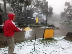
Lightning and thunder had woken us a couple of times through the night and we awoke to some heavy rain. Still, we were on a tight schedule and pedalled out by 8:30 – almost soaked by the time we’d left the gate. We’d been warned of the climb out of Omeo and within a couple of k’s we’d reached the bottom. It was an incredibly long, slow slog up in the ‘granny gear’, getting absolutely saturated. The quality waterproof panniers were worth their weight in gold. The Kosciusko lookout was just thick mist and finally, a straight hour of climbing later, we’d made the top. It was cold and even trying to layer up for some descending to Cobungra couldn’t prevent Billy from shivering through a short food break at the revamped Cobungra CFA Station (surely Dartmoor is due for a new shed?). We had budgeted time for having a full lunch on the trangia but needed to keep pedalling to keep warm. Going past the alpine sled-dog company stirred the huskies and we were given a howling reception into the snowgum line. It was steady climbing most of the afternoon – one stretch of road with less hills and a break in the rain was very welcome but the forecast still suggested imminent snowfall. One bloke out of the blue overtook us on his racer – going from Omeo to Harrietville and back, an extreme effort! Arriving in Dinner Plain was very welcome; soaked and shivering we only had to wait 10 minutes at the Hotel High Plains to be let in. We had the place to ourselves off-season and appreciated a heater, hot shower, and washing machine. The first snowflakes caused excitement and after a couple of hours of build-up we were able to go play in it! In a ‘return to the past’ we were able to write the purpose of our ride in the snow – ‘Cycling The Divide for MSF’ – just as we had traced ‘Cycling Across Borders for MSF’ on the Grimsel Pass, Switzerland in 2007. The rest of the evening was some R&R, TV and another cup-of-soup/packet-rice special feast. Luxury!
-

- Day 3 Getting saturated
-

- Day 3 Montage to Dinner Plain
-

- Day 3 Snow sign “Cycling the Divide for MSF”
-
- Day 3 Totem Tennis
Day 4: Dinner Plain to Myrtleford. 105kms, via Mt Hotham, Bright. “Going down”
104kms, 576m total climbing, 1893m total descending, 1322m elevation lost, avg 20.8kmh.
If yesterday’s light flakes were unexpected the scene we awoke to was surreal – centimetres of snow laying on the ground; more than enough to build a snowman. Even better, there was no precipitation and it was completely still, so while the climb to Mt Hotham was very crisp, the road was dry and the riding exhilarating with the surrounds having a dusting of snow. The air must have been thinner though, because we were certainly puffing. The summit was cloudy and we took a stop to check over maps and consider a walk – a well informed CFA volunteer suggested there would be nothing to see, and he would know, as he is posted to the fire watch tower in summer; often there are hours in a row with cloud enveloping him. We put all our layers on and zipped up as we left the summit, although we didn’t realise there were still a few decent climbs out of saddles before the real descending began. The long gradual descent gave some great views through forest and mountains, with recent fires evident in the stands of gaunt trees. It was our fastest patch of riding, although many corners prevented us getting too much speed up. ‘The Meg’ climb had a lot of cyclists slogging up the other way, and when we got to Harrietville we could see the beginnings of the strong regional cycling culture. A quick food stop (we didn’t have much left) then we trundled the slightly downward 22kms to Bright, in lovely sunny conditions stopping only for smoked salmon at the fish farm! The Bright Brewery seemed like cycling mecca, with brews plastered in bicycle motifs and fan-art along the walls. The neighbouring bike shop provided no shortage of people wanting to chat out the front, curious as to our heavily laden voyage. The beer went down very well and so did the rolls we made with our salmon treat. We jumped on the rail trail which to our surprise is completely sealed for its length. Cruising out of Bright, through Porepunkah and along the Ovens River was very scenic and could easily make us come back again. There was a slight headwind but we punched into that well enough and were in Myrtleford just after 4pm. Our accommodation for the night was with hosts Phil and Joyce from WarmShowers, although it meant an extra 7kms riding out of town – the undulations to get there still sapping despite our ‘downhill day’. A delightful evening going over our respective bike tours, with Phil and Joyce having tackled extreme climbs across Europe – on a tandem! Their legs were certainly tougher than ours. We pitched tent in the yard and slept soundly after a long day and filling dinner.
-

- Day 4 Snowman
-

- Day 4 Dinner Plain
-

- Day 4 On the Road
-

- Day 4 Climbing to Hotham
-

- Day 4 Descending Hotham
-
- Day 4 Descent
Day 5: Myrtleford to Beechworth, Wangaratta. 85kms, via Buckland Gap, Milawa. “Rail trail delight”
83kms, 560m total climbing, 679m total descending, 120m elevation lost, avg 18.5kmh.
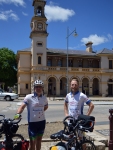
It was our earliest morning of the week – up at 6 to enjoy a beautiful sunrise over the valley and on the bikes by 7. We breakfasted in Myrtleford with Iced Coffee as a plain milk substitute in our muesli – no 600ml milk for sale, but the caffeinated milk may become a regular thing now? It’s sooo goood! A few extra discussions about alternative routes to Beechworth and we settled on the most direct, despite it not being recommended by our hosts who noted it’s a narrower and faster-trafficked road than via Stanley. But apart from being shorter, the 300m climb was the also the lesser of the options. Initially on rail trail, then onto the Buckland Gap road which indeed had no shoulder. We did ok though with only a few discourteous and disconcerting vehicles. While resting at the foot of the hill pre-climb another cyclist stopped by for a chat, followed by the Highway Patrol who seemed to want to satisfy themselves that we were carrying helmets. They flew away then we slogged up the 13% hill, sweating and thinking we would be glad to be done with this hill-climbing business. The last few k’s into Beechworth were recuperative and we’d arrived in good time, meaning we had a very casual couple of hours to peruse town. Coffee first at the recommended Blynzz Cafe, then some walking through the historic centre chatting history, including Dartmoor’s connections to this region and some bushrangers including Ned Kelly. [Do you know a local named Creed once applied for funds from the government to catch the infamous outlaw. But he couldn’t pursue him full-time because he had to be home for shearing!] A theme had developed, with a beer and lunch at the Bridge Rd Brewery. Well-earned…again. We made sure to get some ‘Beechworth’ photos, including a trip to the put-it-on-the-map bakery, then we struck out on the rail trail again. This section is magnificent – beautiful landscape (and going downhill might have helped our impressions). A bizarre Echidna incident had us shaking our heads in amazement for hours, rueing the missed opportunity for viral internet fame. Upon approaching we stopped and watched it waddle along, scratching its hindquarters with a back foot every few steps. Getting within a metre it was still oblivious to its viewers, and while Billy snapped photos it suddenly flipped onto its back and gave a smug belly scratch for seconds; rolling back over it took a few more steps then guiltily realised we were right behind, huddling down to hide in embarrassment. Sadly the phone was set to taking photos and not video! We stopped at Everton Station – a rail junction in the late 19th century, apparently thriving and with high patronage, now just a house or two. Yet Dad’s Aunt had written postcards back and forth with the then-station-master’s daughter, part of his ongoing research into the now National Museum in Canberra collection. We took an alternative route to Wangaratta via Milawa, meaning we had some roads to travel and wine and cheese to taste (and purchase!). It was a comfortable final dozen or so kilometres into Wangaratta despite some headwind – the satisfaction of completing the trip pushing us on. We were able to utilise the brand new Merrawa Park Bike Hub – an incredible facility including public bike lockers, tools and hot showers. The 3 hour train ride to Melbourne was far more comfortable because of it. The final link was cycling under lights from Southern Cross Station to Maggie’s home in West Brunswick at 10pm. We were done.
-
- Day 5 Sunrise Myrtelford
-
- Day 5 Beechworth
-
- Day 5 Lunch Break
-

- Day 5 Rail Trail
-

- Day 5 Echidna
-

- Day 5 Everton
-

- Day 5 Finish in Wangaratta
TOTALS: 365kms, 4333m climbing, 4178m descending, 155m elevation gained, avg 16.5kmh.
Other reflections: The most impressive of the riders we talked to was hard to pick: the couple on a year- long circumnavigation of the continent, the crazy bloke going Omeo to Harrietville and back, Chrissy from Bright doing the upcoming India-Pacific Wheel Race next March, or Phil and Joyce the indefatigable tandem team.
How do you pass the time while pedalling constantly? Just keep pedalling.
Most useless item packed? Tough competition…the trangia [underused but still useful], too many clothes [but lycra is light], two medical kits [maybe just lucky we didn’t need them]… No, it would have to be Dad’s picked-up spanner – you can have too many shifters!